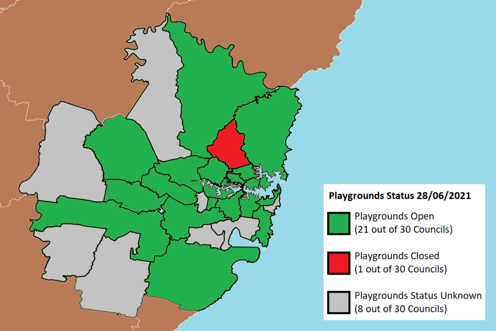
Council has closed the library, pool, and a range of other indoor community facilities in line with public health orders. Our sports ovals and customer call center remain open.
However at this stage Ku-ring-gai is the only council in the Sydney Metro region to have actively closed off our playgrounds. Some of our residents have found this strange, especially given the general support for outdoor exercise in small groups and also the school holidays, so yesterday I asked council staff to provide clarification on this matter.
At this stage I can say that there are some differences in interpretation of the public health order and our staff have reached out to the State Government for further clarification. In the meanwhile, staff have taken a precautionary approach by closing the playgrounds given the higher transmission rates of the Delta variant.
Personally I’m not informed enough to make a call on whether this is ‘right’, however I haven’t personally been encouraging my children to touch anything whilst out on the daily walk.
For the latest status on service & playground closures, refer to the link below.
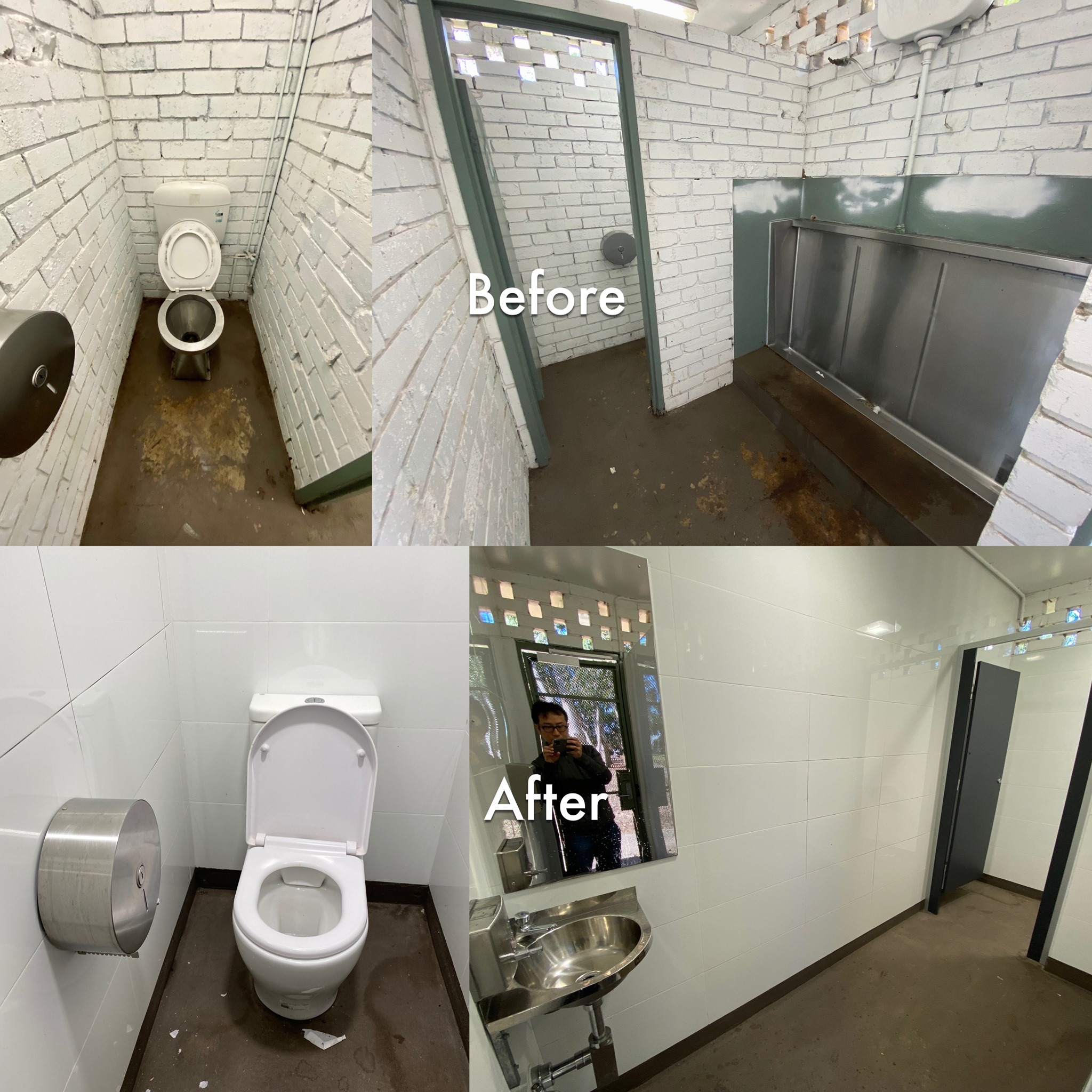
🚽 Have you ever tried to use a public toilet and thought ‘eww this place is gross’? Each year Council upgrades some of its public facilities. Pictured below is an upgrade that happened earlier during the pandemic, where the prison-style toilets at Queen Elizabeth II Reserve were upgraded to something cleaner, brighter, with a functional mirror and energy/water efficient fixtures. It makes for a pleasant and safer experience for our residents at West Lindfield.
To all those who are about to enter lockdown, I wish you well. Many school holiday plans cast aside and much restlessness at home.
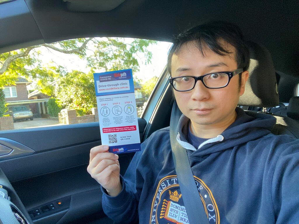
If you have any symptoms, please get tested as we need the data to protect the public. I had to get a test earlier this afternoon at Killara, the queue went all the way back to Nelson Road but at least it was all done in the comfort of my car. All up it took about twenty minutes which was a real surprise.
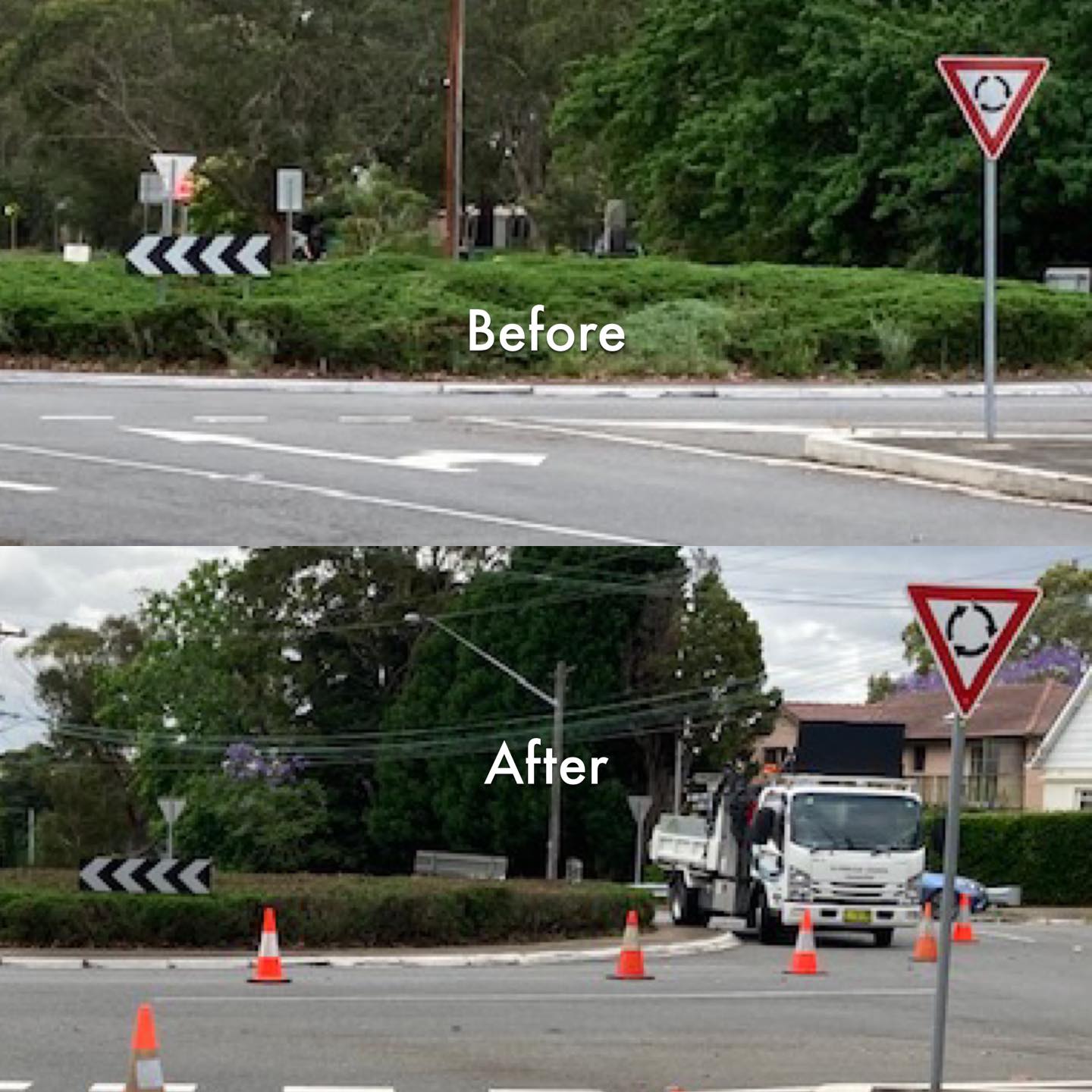
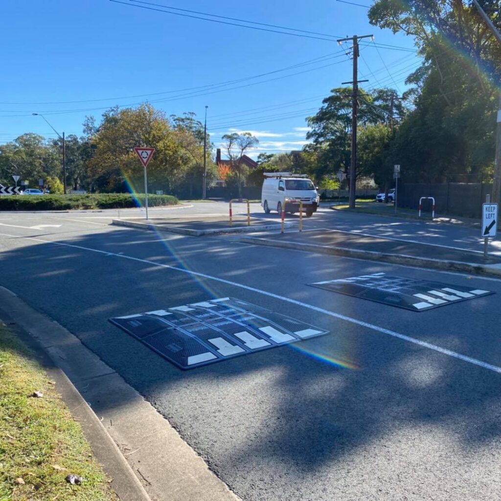
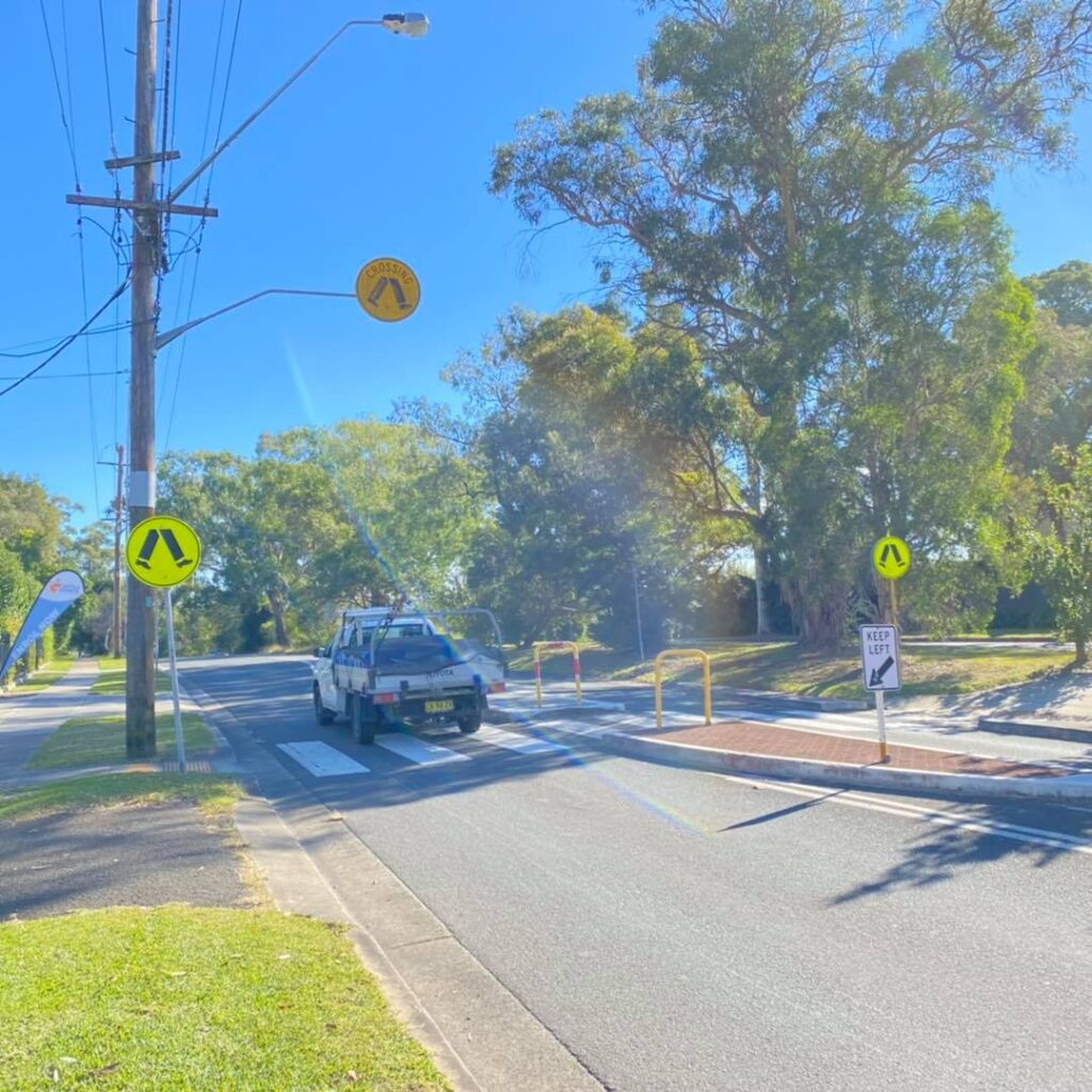
I met up with residents a few months ago to discuss safety issues on Lady Game Drive.
To improve visibility of vehicles at the roundabout, the feral hedge was trimmed back.
To make the entry to the roundabout a bit safer for pedestrians, speed cushions were added to slow the traffic (a request for a zebra crossing was declined).
Council also has State Government in principal support to install a wombat crossing (raised zebra crossing) at the school crossing on Lady Game Drive. Next steps with this is to find a source of funding the project, but I hope to see it in the near future.
I believe it’s important for councillors to invest in professional development so that they can better serve the community. These last two years I’ve been completing an MBA at my own expense and was recently selected to go on MBA Exchange at Oxford. It’s a shame that international borders are closed because I miss out on the travel and networking experience, but I know that what I’ve learnt regarding land use, valuations, emerging trends, as well as the role of debt and risks with large scale developments will be of use when it comes to building our community hubs in Lindfield, Turramurra and Gordon.
Thanks to AGSM at UNSW Business School for giving me this opportunity.
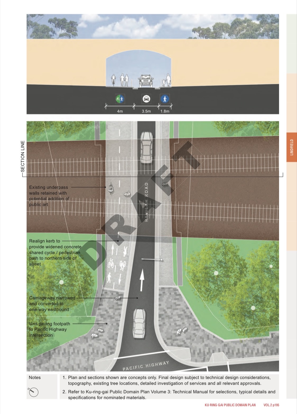
Public Domain Plan (including Havilah Underpass) – Councillors asked for a site inspection to better understand the issues. Matter deferred to July or August.
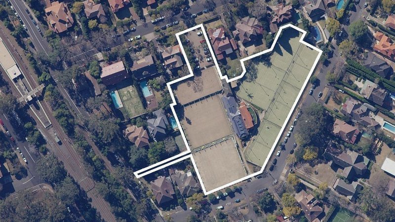
Killara Bowling Club and Lawn Tennis Club – Council to work towards heritage listing the site.
Mona Vale Road – Council to ask the State Government what can be done to improve cyclist safety.
St Ives Showground – Council to ask the State Government to investigate measures to make the entry / exit on Mona Vale Road safer. Measures to be investigated may include traffic lights and a reduced speed limit.
Local Character Background Study – Document amended to reflect community feedback and adopted. Indicative timeline of next steps to be provided to councillors.
Roseville RSL – Majority of councillors voted to adopt site specific development controls for the site to allow for seven storey apartments.
Confidential Item: Land Acquisition for Open Space and Public Roads and Divestment of Surplus Council Land – Majority of councillors voted to support the staff recommendation. I voted against this because I don’t like voting in relation to the sale of assets when members of the public don’t know which public assets we are talking about.
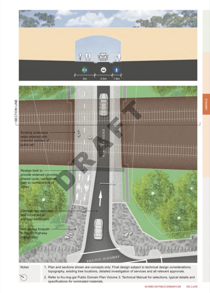
Many residents have contacted councillors in the past week with objections to council staff’s proposed plans to remove the westbound lane of the Havilah Underpass and replace it with a cycleway.
I will answer the most frequently asked questions below.
If the westbound lane is removed, how will we get to Coles, to Holy Family, to Highfields, to West Lindfield and beyond?
In addition to the removal of the westbound lane in Havilah, traffic lights will be installed at the intersection of Strickland Avenue and Pacific Highway. The staff (most who don’t live locally) believe that this will be sufficient to offset the loss of westbound Havilah, however as a local resident who knows just how bad both Havilah and Strickland can get even in the current state, my gut feel is that the proposed changes won’t be enough to allow effective flow and will have unintended consequences (especially at the intersection of Strickland and Lindfield Ave). This is also the view of many other residents that I talk to.
In the future residents on the East side wanting to head North on Pacific Highway via traffic light, there will only be four options. Roseville’s Clanville, Lindfield’s Strickland, Killara’s Lorne, and Gordon’s St Johns.
Has there been any statistics or modelling of traffic at these intersecitons?
There was a 2014 report on traffic in the Lindfield Town Centre. If you look at pages 34, 36 and 38 of the report, it indicates that Pacific x Balfour was one of the worst intersections and required attention. I think it’s important to note here that the study is nearly 7 years old and that traffic conditions are arguably worse today.
Is Balfour x Pacific dangerous? What’s the crash history?
In the five years from 2010-2015 there were 23 recorded crashes, 5 of which involved vehicles turning right from Balfour and conflicting with pedestrians.
In the five years from 2015 to 2020 there were 5 recorded crashes, 1 of which involved vehicles turning right from Balfour and conflicting with pedestrians.
Sometime between 2013 and 2016, Transport for NSW installed a no right turn light at this intersection and this appears to have reduced the number of pedestrian collisions.
Why is the performance of this intersection so bad?
Local residents know that it’s because there are cautious drivers who want to turn right but don’t want to creep into the middle of the intersection to allow the vehicles behind them to go straight or turn left. This causes unnecessary holdups and worsens the performance of the intersection.
What are Transport for NSW’s priorities?
Transport for NSW prioritises the overall network performance of state roads and generally holds these with higher regard than traffic issues at local roads. I’ve previously presented sensible solutions / requests to them about other network performance or safety issues at intersections such as Archbold x Boundary, Pacific x Clanville, Lady Game x Delhi, Boundary in front of the Roseville Chase shops and on each occasion the focus of non-local staff is on state road performance without understanding whether reasonable adjustments can lead to overall better state and local road performance.
With regard to the Lindfield Town Centre, their priority is the performance of Pacific Highway so a simplified version of their logic is that if we add a traffic light at Strickland, something else has to go (i.e. Havilah). Hence Transport for NSW has been in discussions with Council Staff about the possibility of turning Havilah into one way.
Having said that, the Havilah one lane is only one of many options and I think it’s reasonable to say that there may be other solutions that improve State and Local network performance without severely compromising the Pacific Highway. One such suggestion by local residents as well as our State MP Jonathan O’Dea (in his submission to the public domain plan) was to leave Havilah Underpass as two lanes of traffic with a no right turn onto Pacific during peak. With the no right turn in place, the flow of traffic from the East will be much smoother and without significantly impacting the performance of the Pacific Highway (in fact it may improve Pacific Highway performance as we won’t have cars unnecessarily going south to Strickland and then driving back up North on the highway towards Coles / Holy Family / Highfields). I haven’t seen any evidence that this suggestion from residents and our State MP has been seriously considered or modelled vs. the one way design.
What about widening the underpass to three lanes?
The railway bridge and the underpass is a state government asset so it requires state government funding to widen. If you look at the structure it’s obviously quite an expensive project. I asked our State MP (again) about this last week and due to the cost-benefit of such a proposal along with the significant needs elsewhere in NSW, it’s not a current priority.
We are, however, getting pedestrian lifts at Roseville and Killara Station and so that’s something that we can appreciate.
What about a right turn green light similar to St Johns Ave x Pacific?
Right turn green lights only work if you have two lanes of traffic heading out. With the current arrangement we only have one lane of traffic out and we cannot create space for a second lane of traffic out without significantly reducing the pedestrian walkways, relocating traffic light and streetlighting poles, having to redo the support structures of the railway bridge, etc. It’s an expensive exercise for limited benefit (and the no right turn during peak sign would be much more cost effective).
Will Councillors move a Notice of Motion for a cost-benefit analysis of a pedestrian tunnel?
What I plan to do with this is to instead raise a Question with Notice and have the answers published in the July or August council papers. Council staff are required to answer Questions with Notice, whereas a similar Notice of Motion will be subject to councillor vote and will likely fail.
I will ask council staff for a high level cost-benefit analysis and let’s see what answer they come up with.
My gut feel is that it’s going to be very expensive and we won’t have any way of realistically funding it. Council (when going down its current resolved path) has found it challenging to deliver things like the Lindfield Village Hub and a Pedestrian Bridge, so if those are already a challenge to fund then a properly built 90m pedestrian tunnel even more so.
What’s this that I hear about Transport for NSW prioritising pedestrians and cycleways over vehicles?
Link to the document below. My gut feel is that the document is simplistic, a bit ambiguous, and can lead to interesting interpretations and outcomes.
I agree, I’m a cyclist as well and I think it’s perfectly fine to use the road on this occasion if it means we can retain two lanes.
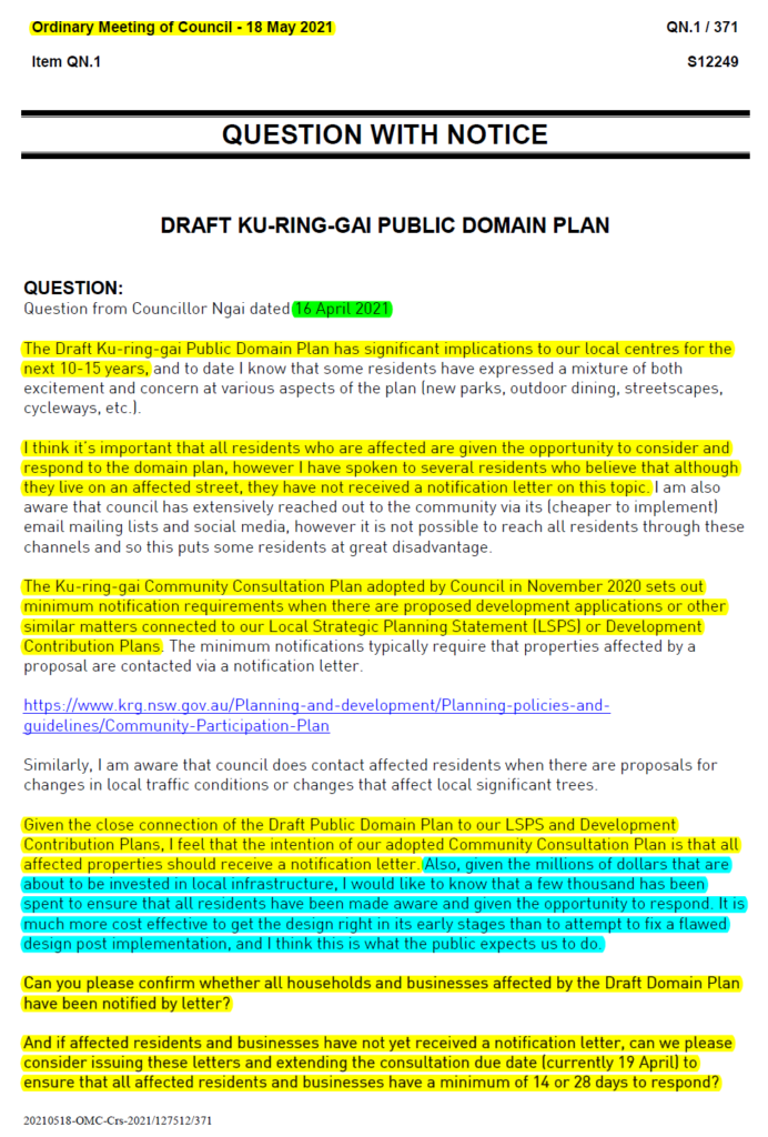
Why are we in this situation where significant changes are made to town centre plans without extensive consultation with the public?
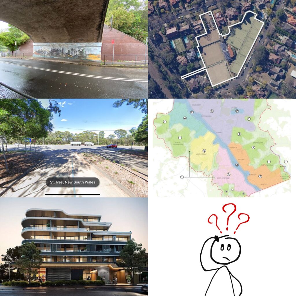
My personal view is that when significant changes like this are proposed ($24m plan to revamp Turramurra, Gordon and Lindfield), residents should be notified by mail and invited to provide feedback.
When I ask council staff about sending out notifications by mail, the general message is that notifying residents by mail is expensive and not required. Instead the preference is to rely on council’s email newsletter and advertisements in the North Shore Times.
I don’t agree with this approach, and I also think it’s inconsistent with the Ku-ring-gai Community Consultation Plan adopted by Council in November 2020. The community consultation plan will need to be reviewed to remove any ambiguities. Refer to the attached pictures for more information.
At this Tuesday’s council meeting we will be voting on whether or not the Killara Bowling Club and Killara Lawn Tennis Club Sites should be established as a proposed heritage item (GB13). What does this mean? When a property is heritage listed, it’s usually a limited or unique asset which we aim to safeguard so that present and future generations can learn and benefit from it. The property is then recognised under law, a stricter standard and approvals process is applied for development on the site, and the government provides extra support for heritage owners to upkeep their site in the form of grants, reduced council rates and reduced taxes. And in this particular case, I personally believe the site should receive such protections.
How do we decide what to heritage list and what not to heritage list? Heritage experts usually assess a potential site based on eight criteria. These are:
Importance to cultural or natural history
Possession of uncommon, rare or endangered aspects of our cultural or natural history
Potential to yield information to contribute to our understanding of our cultural or natural history
Ability to demonstrate principal characteristics of a cultural or natural place or environment
Ability to exhibit particular aesthetic characteristics
Importance in demonstrating a creative or technical achievement at a particular period
Special association with a particular community or cultural group (including indigenous)
Special association with the life or works of a person or group of persons important to our history
Heritage listings occur quite regularly at Ku-ring-gai but what I’ve found these four years is that proponents of heritage listing are often advocating heritage listing for the wrong reasons. Their reasons are not the eight criteria mentioned above, rather, they are using heritage listing as a proxy for preventing further development and congestion. And in the case of the Killara Bowling and Lawn Tennis Club Sites I’ve certainly met some residents who are using heritage as a proxy for anti-development (there’s also some internal drama within and between the two sporting clubs).
My job as a councillor is to vote on heritage listing based on the eight criteria above and my feelings regarding development, traffic congestion, internal political dramas, etc. are not relevant. So in this particular case of Killara Bowls/Tennis, based on the information available to me, I do think that the site meets the threshold for Local heritage listing (but not State, National or World). How will the other councillors vote on Tuesday? We will find out soon.
Here’s a video of a wallaby and her joey at Bates Park, 97 Babbage Road Roseville Chase. It’s quite sweet and there are more videos like this on the Facebook page.
Four years ago and just three months before the council elections (i.e. before my time as councillor), council voted unanimously to divest (i.e. sell) Bates Park. You can look it up in the council minutes, 13 June 2017, GB4.
Why does council sell assets? Well the theory is that underutilized assets are sold so that we have the funds to create new assets in areas where there are much greater needs. Some examples from recent years include:
Lindfield Village Green (under construction)
St Ives Basketball Courts (future project)
Marian Street Theatre (future project)
Cameron Park Expansion (required the purchase of 2, 4, 6 and 8 Gilroy Road)
Boyds Orchard Park (which required council purchasing 23, 25, 27, Duff St and 1 Holmes St)
Of course it would be even better if we didn’t have to sell any assets at all because once an asset is sold, it is very difficult for that land to be bought back. But the reality of how councils are funded in NSW is that rates are pegged and set by the Independent Pricing and Regulatory Tribunal, and the rates that councils collect often fall short of what is actually required to deliver services and assets to the standard that ratepayers expect. This puts councils in awkward positions where they then have to consider selling some assets to create other assets.
But while I understand the rationale behind asset sales and am sympathetic to the financial constraints that most councils face, the question remains. Should we be selling community assets and if so, which ones?
What about Bates Park (which the previous council has already authorized for sale but has not yet been sold)? Should Bates Park be sold? If it’s sold for half a million, is it a worthwhile transaction given the habitat loss for wildlife? What if it’s sold for 5 million? 50 million? Where do we draw the line between sell and no sell? And if it is ever sold, shouldn’t at least some of the money be reinvested in local infrastructure such as the footpath on Babbage Road that local residents have been asking for? [I’ll talk more about this in another post.]
I’m quite conscious that each of us live in homes which used to be bushland, so in some ways you could argue that it’s hypocritical for us to argue that we continue to receive benefit when others cannot. But you can flip it the other way and say that given the significant habitat loss already, should we not seek to protect what remains? Are there some parts of bushland that are more worthy of protecting than others? How many $$$ does an asset need to be worth before it is considered better to sell for development than to retain for wildlife? What if there are endangered species on the site?
Here at Ku-ring-gai, we often talk about heritage value and we go to great lengths to protect heritage. But I find that our views on heritage are quite limited to buildings. The moment there’s an old building of some arbitrary value, we’re quick to wave the heritage flag. But what about flora and fauna? Don’t they have some sort of ecological heritage value?
At this stage I’m not (officially) saying that there’s a specific right or wrong. I’m not picking sides but I want to draw out the issue and hear what you as residents have to say on the matter. Ultimately my job as a councillor is to represent you, and I cannot do my job without hearing what you have to say on matters such as these.
Let me know what you think. My job is to represent you.
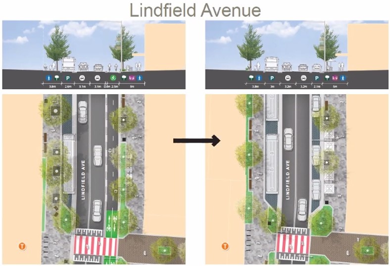
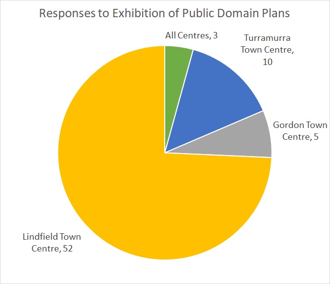
Thank you everyone for your submissions to the Ku-ring-gai Public Domain Plan. We received over 50 submissions in relation to Lindfield’s extensive pedestrian, cycleway, parking, outdoor dining and traffic flow changes, and council staff have amended the proposed plans in response to this.
Positive amendments include the removal of the proposed dedicated cycleway immediately in front of the shops on Lindfield Avenue. This allows for more ground-level parking which residents, especially the elderly, have told me is something that they value. I don’t think cyclists are disadvantaged by this change as the plans retain the dedicated cycleway on Lindfield Avenue North and South of the shops, and the lane immediately in front of the shops has and will always be a safe, low-speed area which cars and bicycles can easily share.
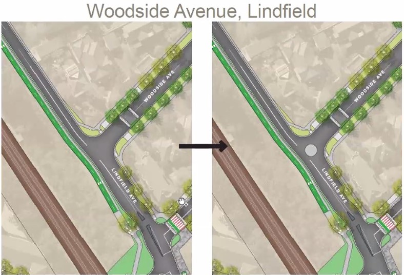
Another positive change is the retention of what is currently a temporary roundabout at the intersection of Lindfield and Woodside Avenue.
The most controversial remaining issue is the Havilah Road Tunnel, which faces a reduction from two lanes of traffic to only one lane. The outbound lane onto Pacific Highway is proposed to be given up, making room for pedestrians and cyclists. Under this proposal, people wanting to exit onto Pacific Highway will have to use other options such as Strickland (with traffic lights installed), Treatts, or Lorne.
If you would like to see further amendments to these plans, there is one more opportunity to do so. Prior to the council meeting on 15 June, there is also a “public forum” on 08 June where members of the public can each speak for 3 minutes on anything they want (including these proposals for changes to traffic flows). More information on how you can register to speak at the public forum (by Monday 07 June 5pm) can be found in the following link.
It must also be noted that these are high-level concept plans for desired long term outcomes and some proposed concept designs have remained the same in the final plan. In most instances additional funding or further studies, collaboration with Transport for NSW, changes to the LEP and DCP or targeted community consultation, or all of these, will be required to realise these designs. Though the design intent has been demonstrated, the final design may be delivered differently.